mapping

TECHNOLOGY
Four 'smart' mapping successes
Airborne surveys could reduce the need for exploratory drilling
08 July 2024
TECHNOLOGY
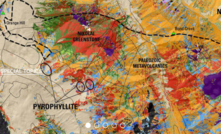
US uses geological mapping to shape critical minerals strategy
Supported by IIJA funding, the Survey is using advanced mapping to locate strategic commodities
09 April 2024
PARTNER CONTENT
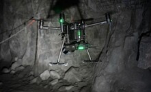
Hovermap a SLAM dunk for safety
Changing the way underground mines conduct inspections and monitor deformation
11 January 2022
TECHNOLOGY
Newlab, Vimson Prospect Mining Studio selects start-up cohort
Companies selected for research, technology ecosystem initiative
20 April 2020
EXPLORATION
Rupert Resources uses Exyn autonomous drones at historic mine
Exyn's autonomous drones map historic gold mine in northern Finland
02 March 2020
OPERATIONS
Woolpert taking to the air for new mining contracts
Firm will perform aerial mapping, surveying for two global mining clients
19 December 2019
OPERATIONS
Terra Drone Mining taking off
Terra Drone's new subsidiary specialises in underground mapping, inspections
11 December 2019
TECHNOLOGY
ASI augments algorithm for autonomous obstacle avoidance
Occlusion mapping algorithm to help detect drop-offs and large negative obstacles
02 December 2019
PARTNER CONTENT
Bringing the future to mining customers
Saso Kitanoski, Metso’s President, Consumables sits down with Mining Magazine to share his insights on industry trends
PARTNER CONTENT
Designing a Resilient Future: Innovation & Digital Transformation in Natural Resources
Buzzing Perth roundtable picks the brains of sector leaders to help shape the resources
PARTNER CONTENT
Navachab Gold Mine boosts recovery & cuts OPEX with STEINERT's sensor sorting technology
Navachab Gold Mine, a low-grade gold ore operation, upgrades its very low-grade ore resources using STEINERT’s suite of innovative dry sorting processes.
PARTNER CONTENT
Vale's circular mining vision: turning waste to value
Vale’s Bruno Pelli shares how circular practices turn mining tailings and waste into


ESG Index 2025: Benchmarking the Future of Sustainable Mining
The ESG Index provides an in-depth evaluation of the ESG performance of 60+ of the world’s largest mining companies. It assesses companies across 10 weighted indicators within 6 essential ESG pillars.

Automation and Digitalisation Insights 2025
Discover how mining companies and investors are adopting, deploying and evaluating new technologies.

Mining IQ Exploration Insights 2025
Gain exclusive insights into the world of exploration in a comprehensive review of the top trending technologies, intercepts, discoveries and more.
Future Fleets Insights 2025
Mining IQ Future Fleets Insights 2025 looks at how companies are using alternative energy sources to cut greenhouse gas emmissions
THE ASPERMONT BRAND PORTFOLIO


Copyright © 2026 Aspermont Media Ltd. All rights reserved. Aspermont Media is a company registered in England and Wales. Company No. 08096447. VAT No. 136738101. Aspermont Media, Moor Place, 1 Fore Street Avenue, London, England, EC2Y 9DT.